
Your Guide to Commuting from Tri-Valley to San Francisco
Planning a commute from Livermore, Pleasanton, Dublin, San Ramon, or anywhere in the Tri-Valley to San Francisco? You’re in the right place. This comprehensive guide breaks down commute routes, transit options, time and cost, lifestyle insights, traffic tips, and everything in between.
Why Tri-Valley to San Francisco Commuting Matters
The Tri-Valley, which includes Livermore, Pleasanton, Dublin, and San Ramon, is one of the fastest-growing residential areas for professionals who work in San Francisco. With excellent schools, more affordable housing than the Peninsula or Marin County, community amenities, and beautiful open space, it’s no surprise commuters are choosing to live here and travel into the city each day.
But commuting from the Tri-Valley to San Francisco comes with unique challenges and opportunities. This guide provides real-world answers to the questions people search online:
How long is the commute from Tri-Valley to San Francisco?
What are the best transit options?
How much does commuting cost?
Is it worth living in the Tri-Valley if you work in San Francisco?
How can I make my commute easier and more productive?
Let’s dive in.
How Far is the Commute from Tri-Valley to San Francisco?
Many people that commute between the Tri-Valley and San Francisco ask how far the commute is.
Average Driving Distances:
Livermore to San Francisco: ~50–60 miles
Pleasanton to San Francisco: ~40–50 miles
Dublin to San Francisco: ~35–45 miles
San Ramon to San Francisco: ~45–55 miles
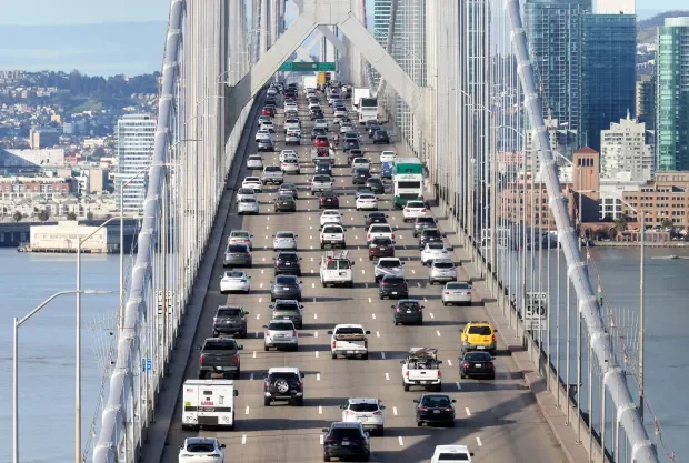
Your actual commute time depends heavily on time of day, route chosen, and traffic conditions, especially through Interstate 580, Interstate 680, and the Bay Bridge corridor.
Peak commute times (weekday mornings ~6:30–9:30 AM and evenings ~4:00–7:00 PM) can significantly extend travel time.
Top Driving Routes from Tri-Valley to San Francisco
While all Tri-Valley commuters ultimately funnel toward the Bay Bridge, the best driving route to San Francisco depends on where you’re starting. Livermore, Pleasanton, Dublin, and San Ramon each have slightly different freeway access points, which affects both drive time and traffic patterns.
Below is a city-by-city breakdown of the best route, along with alternate options drivers commonly see in Google Maps.
Pleasanton
Pleasanton commuters benefit from access to both I-580 and I-680, giving them more routing flexibility.
Best Route (Most Common): I-680 N → I-580 W → I-80 W → Bay Bridge
This is the fastest and most frequently recommended route in Google Maps.
Distance: ~40 miles
Typical drive time: ~50–55 minutes
Tolls: Yes
It’s often labeled as the fastest route despite usual traffic and is the go-to option for downtown San Francisco and Market Street commuters.
Livermore
Livermore sits farthest east in the Tri-Valley, which means commute times tend to be the longest, but routes are straightforward.
Best Route: I-580 W → I-80 W → Bay Bridge
This is the primary and most efficient route for Livermore commuters.
Distance: ~50–55 miles
Typical drive time: ~60–75 minutes (longer during peak hours)
Tolls: Yes (Bay Bridge)
Drivers head west on I-580, passing through Pleasanton and Dublin before merging onto I-80 West and crossing the Bay Bridge into San Francisco.
Dublin
Dublin is positioned closest to the I-580/I-680 interchange, making it one of the most flexible Tri-Valley cities for commuting.
Best Route: I-580 W → I-80 W → Bay Bridge
For most Dublin residents, this is the most direct and efficient option.
Distance: ~35–40 miles
Typical drive time: ~45–55 minutes
Tolls: Yes
This route minimizes freeway changes and is ideal for commuters heading to downtown San Francisco or the Financial District.
San Ramon
San Ramon is located north of I-580 and directly along I-680, which gives commuters two primary freeway corridors to reach San Francisco.
Best Route (Most Common): I-680 N → CA-24 W → I-80 W → Bay Bridge
This is often the most natural route for San Ramon commuters, especially those starting closer to central or northern San Ramon.
Distance: ~45 miles
Typical drive time: ~55–65 minutes
Tolls: Yes
Passes through Walnut Creek and the Caldecott Tunnel
Google Maps frequently suggests this route during peak hours because it avoids merging south onto I-580.
Strong Alternate Route: I-680 S → I-580 W → I-880 N→ I-80 W → Bay Bridge
This route works better if you live closer to the southern edge of San Ramon, near the Dublin border.
Distance: ~45 miles
Typical drive time: ~55–65 minutes
Tolls: Yes
It can be slightly longer in distance but is often favored if CA-24 traffic is heavy, especially during morning rush.
BART Stations Serving the Tri-Valley
Bay Area Rapid Transit (BART) is one of the most popular alternatives to driving, especially for people living in Dublin or Pleasanton.
From either station, you can take BART directly into San Francisco (stations like Embarcadero, Montgomery Street, Powell Street, and Civic Center).
Typical BART Travel Times
Dublin/Pleasanton to Embarcadero SF: ~1 hour
West Dublin/Pleasanton to Montgomery SF: ~1 hour
BART trains run frequently during peak hours and provide a stress-free way to work without traffic.